
Dear Shock partners,
We have received the final evaluation from the Commission
services and the decision taken the 17/11/1999:
"..no financial contribution could be made available to your proposal
entitled....."
The decision was motivated by the following:
"The proposal achieved the minimum threshold scores described in the
evaluation manual. However, your proposal was ranked too low on the
priority list to allow it to be funded, given the limits of the budgetary
resources available."
Scheme of the evaluation scores:
Score go from 0 to 5 for every substep. Step 1 and 3 have only one substep.
----------------------------------------------------------------------------
Step 1 Step 2 Step 3 Total
Points 4 12 3 19
Weighted 40 24 12 76
Result Go Go Go Go
----------------------------------------------------------------------------
Step 1 i: Scientific/technological quality and innovation
It is a good project which addresses a key problem in hazard
assessment using a novel approach.
The potential gain in knowledge outweights the existing risk of
achieving the expected results.
It is innovative and its schedule is carefully planned.
----------------------------------------------------------------------------
Step 2 ii: Community added value and contribution to EU policies
The extension of the historical record is of primary importance for
the seismic hazard assessment in Europe.
The goals cannot be achieved on a national level. It will provide
data for long-term hazard assessment, thus influencing the EU policies in
the long run.
III: Contribution to Community social objectives
The proposal will enhance the awareness of the seismic risk in
areas where earthquakes are considered as a remote threat.
iv: Economic development and S&T prospects
The results will enable more accurate determination of seismic
hazard in areas with poor historical record and might contribute to
methodological advance in seismic hazard assessment.
----------------------------------------------------------------------------
Step 3 v: Resources, partnership and management
The experience of the group for achieving the expected results
cannot be easily deduced by the references listed.
The resource management seems to be inappropriate and the
evaluators suggest significant budget reductions of the order of the ~50%.
----------------------------------------------------------------------------
Best regards,
Shock coordinator
Messina’s waterfront after the earthquake of 7.0 magnitude in 1908
Seismic Hazard Of Karst alpine regions:
the real scenario
EESD-ENV-99-1 Environment and sustainable development
RTD Activities of a Generic Nature
(i) The Fight against Major Natural and Technological Hazards
I.1 Natural Hazards
I.1.1 Seismic risks
Proposal preparation: 07/12/99
Proposal pre-registration # EVG1-1999-00013P
Title
*Table of Content
*Objectives
*Problem
*Solution
*Expected Achievements
*Contribution to Energy, Environment and Sustainable Development RTD Programme
*Innovation aspects
*Project Workplan
*Introduction
*General
*WP1: Project management
*WP2: Specifications
*WP3: Surveys
*WP4: Dating
*WP 5: In-situ measurements
*WP6: Characterisation
*WP7: Modelling and verification
*WP8: Application
*WP9: Dissemination
*Summary
*Gantt diagram
*Pert Diagram
*B1: Workpackage list
*B2: Deliverable list
*B3: Workpackage description
*WP1
*WP2
*WP3
*WP4
*WP5
*WP6
*WP7
*WP8
*WP9
*Annexe I
*References
*Annexe II
*Karst regions are very vulnerable with respect to natural and human-activity related hazards. Over the past twenty years, the residential population and tourism have considerably increased in several European karst mountain regions. This trend is expected to continue. Underestimating the seismic risk scenario, therefore, could have serious consequences due to the lack of adequate measures being taken.
In alpine karst regions there are areas of both high and medium seismicity. This classification is based on present-day instrumental data and fragmented historical sources, and very likely underestimates the real seismic hazard in areas actually considered as relatively safe.
The project will extend and verify existing seismic hazard maps for European karst mountain regions adjacent to high seismicity areas by carrying out an innovative study involving the analysis of structural damage in caves in order to provide quantitative information to be used in urban development planning and management, and civil protection.
Specific objectives are:
Contribution to Energy, Environment and Sustainable Development RTD Programme
The present proposal project will contribute to the following objectives of the Research and Technological Development Activities of a Generic Nature/Natural Hazards/Seismic Risk:
Seismic risk is top priority for the 1999 call, and. the present project will contribute to the followings:
Earthquake hazard assessments have commonly been achieved with some confidence by using instrumental records (up to about 100 years) and historical records (up to about 2,000 years). These records describe surface effects and rarely include observations in underground karst environments. Furthermore, the fragmentary nature of the historical sources, which commonly report earthquake damage only for important towns, cannot provide the real intensity of an earthquake, because destruction can be overestimated (the wrath of God) or underestimated (it occurred in areas of little economic/religious interest). The relatively short historical periods for which reliable seismic hazard data are currently available means that there are great uncertainties about the intensities of the extreme events that structures and systems must be designed for. If objective, rather than anecdotal, data extending back over hundreds of thousands of years can be obtained, then these uncertainties can be significantly reduced, leading to more economic, safer and sustainable construction.
The assessment of seismic hazard in European karst mountain regions is fraught by the following problems, which affect the extent and quality of the fundamental data: 1) lack of inter-regional information due to language barriers; 2) low density of population in the past; 3) a small number of towns of religious and political importance; 4) isolated communities with poor communication routes (mountain passes). However, the investigation of the effects of palaeoearthquakes in underground karst (caves) could provide the only, and therefore vital, quantitative contribution to the assessment of seismic hazard in earthquake-prone regions (Davenport, 1998). Palaeoearthquake information from cave structural geology studies is essential if long-term hazard assessments, which are required for safe siting, design, construction, lifelines, and emergency response infrastructures in seismically vulnerable environments (Davenport and Ringrose 1985; McAlpin, 1996), are to be achieved with confidence. The quantification of palaeoearthquakes in caves should be possible when sufficient field evidence is available for the compilation of palaeoisoseismal maps. These maps require the following: 1) recognition of classes of damage evidenced by deformation, breakage and collapse of cave secondary mineral deposits (speleothems); 2) identification of coseismic displacements detectable at the surface; 3) identification of contemporaneous earthquake events and possible correlation with fault movements through appropriate dating methods and field correlations. In addition, cracking and failure of stalagmites should allow the estimation of the probable peak ground accelerations (Davenport, 1998) necessary to cause detectable speleothem damage. This is an essential datum for producing reliable seismic risk maps that give guidance to designers of structures such as bridges, water and gas pipelines, cable-cars, dams and buildings.
Karst investigations should reveal evidence that not only extends and enhances the existing palaeoseismic records, but probably identifes the only, and therefore vital, clear signals of great earthquakes, because these signals are very well preserved (Davenport, 1998). Cave speleothems dating back over 100,000 years present opportunities for recovering records of the strongest events with long return periods. At the present state of knowledge, although palaeoseismicity investigations from speleothems are increasing in number (e.g. Postpischl et al., 1991; Vittori et al., 1991; Carbon et al., 1998; Delange et al., 1998; Duran et al., 1998), and modelling of speleothem fracturing is attempted (Duran et al., 1998), a European study that evaluates maximum ground acceleration of precisely dated historical and prehistorical earthquakes across a wide, interconnected mountain region is lacking (e.g. Forti, 1999). Such a study would complete the existing RTD project "Evaluation of the potential for large earthquakes in regions of present-day low seismic activity", by optimizing the results for overlapping areas, extending the database and adding quantitative data.
Following on from the above state-of-the-art review of karst palaeoseismic analysis, the proposed project is novel in the following aspects:
The general objective of the Shock project is to forecast the possibility that destructive earthquakes will hit alpine regions considered to be safe in a near future and to improve existing seismic hazard maps. This requires the quantification of pre-historical earthquake ages and maximum surface acceleration.
The Shock project stems from the knowledge that this information is stored in the karst environment, and in particular in fractured and collapsed cave secondary mineral deposits observed by speleologists. To extract quantitative palaeoseismicity data it is necessary to:
This can be accomplished only if also other tasks will be performed to obtain the necessary information on:
For the updating of seismic hazard maps it is needed to extend the existing database which extends back to only 1,000 years ago. The existence of archaeological evidences of earthquake damage dating 2,000 year BP warns about the possibility that the return times of these events are such to represent a real risk in the near future. The project, therefore, will quantify ages and maximum acceleration of earthquakes for a time span of at least 5,000 years.
In addition to updating of seismic hazard maps and database, the project gives importance to the dissemination and general application of the results. This will require:
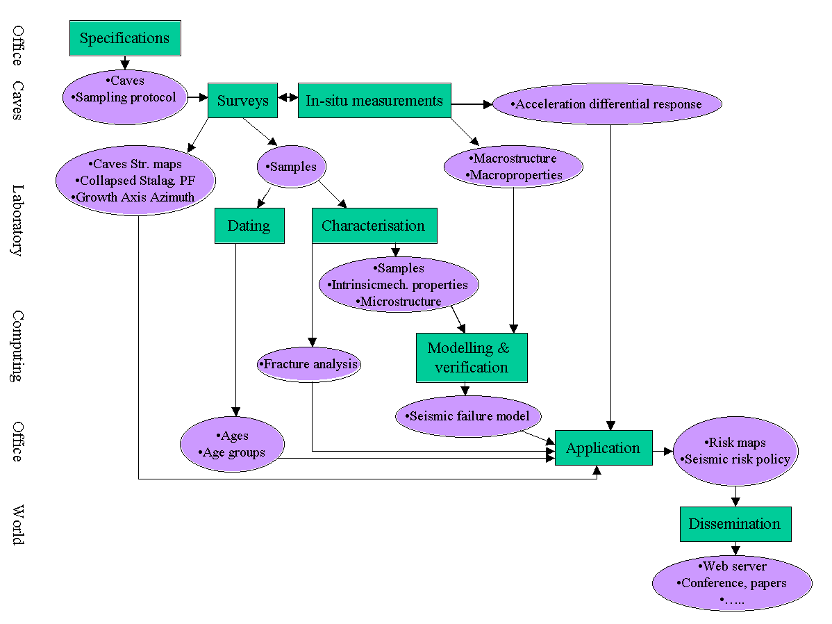
To ensure that the expected results are achieved, the project has been divided in 9 workpackages, which are equally important for the success of the project. Management is the first workpackage as it encompasses the whole duration of the project. The following four workpackages (2-5) are the baseline for all the tests, analyses and modelling that will be carried out through workpackages 6 and 7. The last two workpackages (8-9) are the synthesis of past and new knowledge and are targeted to the application and dissemination of the results.
The structure of the project is summarised in the Pert diagram, and the workplan is illustrated in the Gantt diagram. The technical description in detail of each workpackage follows.
The project plan: the activities of monitoring and controlling the project will be based on the project plan (Gantt). An operational project plan will be prepared (ex. Microsoft Project) complete with resource allocation for each member of the partner project teams while preparing the project technical annex.
This will be used to monitor the information in the progress report preparation procedure (see next paragraph), that will be monitored by enabling effective corrective re-planning of a project level where corrective action within the bounds of workpackage proves impossible. This will enable consideration to be given to the critical path, available slack times between related tasks, dependencies between tasks and resource availability when carrying out the re-scheduling activities. It will also be used as a tool for providing the EU with a rapid project progress graphical overview at any stage of the project, and will be provided together with the project progress report.
Partners responsible for workpackages will also use the project plan as their own planning tool. They will be responsible for the monitoring, control and management of the component tasks. Dependencies between components of their workpackages and components of other workpackages will be evidenced by the project plan, and assure that their own planning activities respect that of others.
Progress Report: these reports will be provided to the EU every two or three months (timing to be agreed with the EU). These reports will be used first and for most to ensure monitoring of the project by involving the partners responsible for workpackages in its production.
The progress report will give workpackage and task planned (from original project pan) finish and start dates against expected (changed expectancy) finish and start dates. In the case of delays explanations will be provided together with corrective actions to be taken. The same will be done for deliverables. Where the partner responsible for a workpackage is unable to supply adequate corrective actions, responsibility is past to the project co-ordinator. The report will also compare resource usage between expected and actual providing explanations of differences.
T2.1: Choice of areas of interest
The project focuses on Italian, Austrian and Slovenian karst mountain areas which show evidence of archaeological and prehistoric destructive earthquakes and for which seismic risk may be underestimated because of their low density of population in the historical past. Geologic, structural and isoseismal maps, and cave registers are available, and will serve as baseline for the selection of key case- studies. Monti Carseolani (Central Italy), Marcesina-Lessini karst plateaus (Northern Italy), Carinthia, Postojna and Skocjan karst areas, and Dimnice and Vilenica Alps (Slovenia) have been preliminary selected as potential study sites.
T2.2: Selection of Caves
Suitable caves will: (i) exhibit evidence of seismotectonic deformation; (ii) contain deformed and broken speleothems; (iii) be easily accessible. A number of 10 caves with evidence of seismotectonic deformation and containing damaged speleothems is ideal because: (i) at least 2 caves per area will be studied, and (ii) 10 is a reasonable number of study-sites to ensure that the work will be carried out within the allocated time. Grotta del Cervo (Carseolani), about 100 km east of Rome, Grotta di Ernesto (N Italy), (iii) Postojna and Skocjanske caves (Slovenia) have been already individuated as potential case-studies.
T2.3 Fieldwork protocol definition
All scientific caving partners should act according to a protocol. Partners will visit the selected cave to identify site-specific problems that must be accounted for in the fieldwork protocol definition. The protocol will be a written text, with contribution from laboratory partners who have specific requests. The protocol will account for conservation policy, and, therefore, speleothem collection will be professional, selective, minimal. By following the rationale presented in Postpischl et al. (1991), recognition in the cave of those seismically damaged speleothems that are most suitable to be removed for laboratory tests is possible with minimum damage to the environment.
T3.1: Structural Geology
Regional tectonics are well known for each region to be studied. The relationships between major regional structures and recent seismicity are also well known. The followings will be carried out:
T3.2: Sampling
Deformed stalagmites and flowstones will be cored and sampled for U/Th dating. Mechanical tests also require small samples that can be cut from stalagmites without unnecessary removal. The larger samples will consist of already collapsed speolethems. Sampling will include:
The dating method uses the natural radioactive decay of uranium. Using the 230Th/U and 234U/238U methods, samples from about a million years old to younger than 50 years can be dated. The U-Th isotopes are measured by thermal ionisation mass spectrometry (TIMS) on 0.1 to 2 g calcite samples, depending on the U content of the sample. Dating will be carried out on a minimum of 100 samples. Outer calcite layers of broken and collapsed stalagmites, fills of fractured and displaced stalagmites, calcite layers immediately above and below anomalous shift of the growth axis and calcite fills of fractured bedrock are the typical specimens suitable for dating palaeoearthquakes. Sample preparation is carried out in a clean-laboratory equipped with a highly-filtered, positive-pressure air supply, and four ultraclean HEPA-filtered laminar-flow workstations for the most contamination-sensitive procedures. The samples are then dissolved in weak nitric acid and subsequently equilibrated with a mixed 229Th-236U spike and then re-dissolved with nitric acid. U and Th are separated using anion exchange columns. The Th and U fractions are then loaded on pre-outgassed, graphite-coated Re-filaments. Isotope ratios are measured by a Micromass Sector 54 thermal-ionization mass spectrometer equipped with WARP filter for very high abundance sensitivity, eight Faraday collectors (for ultra-high precision analyses of large samples), and an ion counting collector (for extremely small samples). The computer-positioned, motorized collectors and highly flexible software permit unattended analyses of up to 20 samples of any mix of elements. On average, a batch of 10 samples is done in 3 to 8 weeks. Typical abundance sensitivity is 5 x 10 -8 at 1 a.m.u. for U and Th main peaks. Because of the sensitivity of the mass-spectrometric technique, dating by the uranium-series (230Th/U) method is done on samples of carbonate as small as a few tens of milligrams, yet with routine precision of better than a percent.
Non-destructive in-situ measurements provide quantitative data necessary for the dynamic characterisation of speleothems.
T5.1: Instrument Installation
In those karst mountainous areas where there is a good chance to record near-future seismic events a cave and the nearest urban centre will be selected to locate high dynamic range seismic monitoring systems that integrate the existing seismic monitoring network. Because of its high versatility, lightweight and low power requirements, the Remote Acquisition Unit (RAU), with a dynamic range of more than 132 dB, three-channel option, sample rate 125 Hz and built-in memory of 20 Mbyte will be used as a stand-alone seismograph or accelerograph. Tri-axial active seismometers with a dynamic range of 155 dB, bandwidth DC to 200 Hz and user-selectable full-scale range will be linked to the remote acquisition unit. When necessary, the acquisition unit will be powered by solar energy. The site-specific seismic response will thus be evaluated by comparing seismograms in digital form from cave and the urban centre stations.
T5.2: Mechanical tests
In-situ sonic and non-destructive artificial excitation tests will be performed to obtain the dynamic behaviour and the stiffness of the whole stalagmite in his natural setting. The data obtained will be compared with the modelling results to verify the correctness of the mathematical constitutive theory.
A data logger characterised by high dynamics and, therefore, capable of sampling ultrasonic frequencies of a few milliseconds will be used to ensure high resolution of the measurements.
T5.3: Seismic monitoring
High resolution seismic data acquisition and processing systems are targeted to the recording of acceleration produced by earthquake of mean magnitude (M > 3.0) in the speleothem environment of formation. The data thus acquired will be compared with data acquired by a similar monitoring system located in the nearest town that is characterised by historical medium seismicity and this differential acceleration will be used to estimate the corrected palaeo-acceleration in the urban area.
Aim of WP6 is to characterise the mechanic properties, crystallography, textures, microstructures and chemistry of damaged speleothems. This characterisation is necessary to assess the mechanic properties and discriminate between fracturing from seismic waves and fracturing for other causes, such as intrinsic physico-chemical properties of the speleothem material, long-term pressure (ice) and load. The followings will be carried out:
T6.1: Mechanical tests
Selected speleothems will be cut accurately and eventually polished by using the diamond saw and metallography sample preparation techniques. Sample handling is important, because of the high sensitivity of the mechanical properties of brittle materials to surface defects. Three and four point bending test, indentation measurements and ultrasonic techniques will be used to evaluate elastic modulus, fracture toughness, rupture strength and hardness of the material.
T6.2: Microstructural analysis
Microstructures and textures of stalagmite material will be analysed to recognise those properties that can be related to earthquake deformation. Microscopy techniques – TEM, Transmission Electron Microscopy and Optical Microscopy- and XRD method (X-ray Diffraction) will be used to identify textural, microstructure and phase changes. Specifically designed computer programs based on a full pattern fitting procedure, are particularly suited for quantitative determination of the relevant chemical, textural and microstructural data. In particular the orientation distribution function will be quantified through texture measurement on a special diffractometer equipped with an Eulerian cradle and a 120˚ position sensitive detector. The spectra collected on the instrument will allow the texture quantification of stalagmite and fracture fill material through innovative methodologies of analysis making use of the entire pattern instead of the polar figures (L. Lutterotti, et al., 1997). The orientation distribution function will be used by the homogenisation techniques in T7.1 for elastic properties computation. Textural analysis also allows to recognise population of tectonically related deformations, which (with the dating) improves the possibility to identify coseismic displacements.
Fracture surface analysis will be carried out on lab-tested specimens and naturally fractured material by SEM (Scanning Electron Microscopy). Regions where fracture propagation started will be analysed in detail. Surface characterisation, quantity and distribution of constituting phases, presence and orientation of micro and macro-defects, textural changes will allow to discriminate between fracturing due to seismic events and fracturing related to ice pressure or load. The proposed approach applies to the characterisation of geologic samples, techniques that are successfully adopted to the study of engineering materials, following a consolidated research protocol The results of T6.1 and T6.2 will be used for WP7, material properties modelling and verification.
WP7: Modelling and verification
T7.1: Material properties
The intrinsic material properties and microstructural characteristics determined in WP6 will be used as input data for the homogenisation techniques to evaluate the proper constitutive model applicable to the stalagmite. In particular, the orientation distribution function, single crystal elastic constants, grain shapes, macro-defects, porosity and the measured stiffness will be used for the computation of the proper elastic model based on the geometrical mean as recently developed (S. Matthies et al., 1993) and Eshelby inclusions theory. The pure elastic behaviour will be extended subsequently to model the fracture damage and crack propagation energy up to the rupture of the material composing the stalagmite. The model in this case will use, as input, the KIC parameter measured on the small samples, the macro-defects and the anisotropic grain shape observable through the characterisation task. Anisotropy, always present in these cave structures, may be responsible for an R-curve behaviour normally not present in traditional ceramic compounds.
T7.2: Shaking table tests
In order to validate and refine the parameterised constitutive model, on one hand, and the numerical simulations of the rupture of the stalagmites which will be described in the following, on the other hand, a few stalagmites will be subjected to earthquake accelerations on a large earthquake simulator (or shaking table) at the University of Bristol. This 3m by 3m shaking table has full control of six degrees of freedom through 50 kN actuators, operating at a maximum frequency of 100 Hz. The actuators are capable of shaking a mass of 15 Mg with accelerations of 1 g simultaneously in each of the three directions of translations. Most of these experiments will be performed on just the stalagmite rigidly anchored at the shaking table, in order to simulate the behaviour of a stalagmite rigidly connected to the rock basement. Some tests will be performed also with an existing large shear stack filled with granular soils in order to analyse the behaviour of the stalagmites founded on granular material overlying a rock basement. This experimental analysis will enable the evaluation of the mechanical properties of the whole system under realistic dynamic loading in terms of deformability, rupture and ultimate collapse.
T7.3: Seismic failure
The failure of the stalagmites subjected to earthquake excitation will be analysed numerically, using the finite element method, the distinct element method and the mathematical constitutive model defined from the experimental data. These analyses will firstly concern the results obtained on the shaking table in order to obtain a proper calibration of the whole method and to evaluate the reliability of the theoretical evaluations. Then, the rupture of the broken stalagmites will be analysed taking account of the actual boundary conditions to which the stalagmite is subjected. A significant effort will be required in order to analyse properly the rupture of the stalagmites that overlay a granular medium, due to the possible amplification of base rock acceleration induced by granular soils. Thus proper constitutive models for the analysis of soil dynamic behaviour will be required. Some typical earthquake accelerograms registered in recent events will be used to perform a parametric analysis of the problem, thus evaluating the maximum ground acceleration which induced the rupture of a given stalagmite and the reliability of this estimate with respect to the ground acceleration history characteristics. A few analyses will be performed on the stalagmite modelled as a three or two-dimensional layered body, in order to evaluate the significant parameters to be used in simpler analyses in which the stalagmites will be modelled as a one-dimensional beam. Data on the influence of various boundary conditions, obtained from a detailed finite element model, will be used as input for a smaller and more refined model for analysing in detail the rupture of a given stalagmite.
T8.1: Data synthesis
Results obtained from age-series, structural survey, tests and modelling will be compared with the existing instrumental and historical records. Quantification of surface effects of major historical earthquakes will be ameliorated through the calibration of the calculated coeval underground maximum acceleration with the data from seismic monitoring. Possible maximum surface acceleration of prehistoric earthquakes will be estimated by considering as baseline the present day different responses between underground karst and surface.
T8.2: Risk evaluation
The results of the comparison between historical and instrumental data and palaeoseismic events recorded in karst will be applied in the followings:
Furthermore:
The dissemination of the results and of the methodology used in the present proposal project is targeted to potential users, political institutions, city planners, civil engineer, karst researchers, engineering students and the general public. Such targeted, and capillary dissemination will be possible because of the specific activities of the partners, that include the followings:
The project will extend and verify existing seismic hazard maps and forecast possible large seismic events in a near future by quantifying ages and maximum acceleration data preserved in the karst environment. At first, the survey of caves and surface will provide samples and characterise the structural geologic setting. Secondly, mechanical properties and material characterisation will be carried out for those stalagmites characterised by dated fractures the textural and microstructural characteristic of which allow the correlation with major seismic events. Material and seismic fracture modelling will be used to determine for such cases the characteristic ground accelerations. Through the synthesis of the data, seismic hazard maps will be updated. These will be the baseline to evaluate the real seismic risk of alpine karst regions considered to be safe on the basis of historical data.
|
Timeline (semester) |
Partners (person/month) |
||||||||||||||||||||||||||||||||||||||
|
1st |
2nd |
3rd |
4th |
5th |
1 |
2 |
3 |
4 |
5 |
6 |
7 |
||||||||||||||||||||||||||||
|
WP1 |
Project management |
15 |
|||||||||||||||||||||||||||||||||||||
|
WP2 |
Specifications |
||||||||||||||||||||||||||||||||||||||
|
T2.1 |
Choice of areas of interest |
2 |
1 |
2 |
1 |
||||||||||||||||||||||||||||||||||
|
T2.2 |
Selection of caves |
3 |
1 |
2 |
1 |
||||||||||||||||||||||||||||||||||
|
|
T2.3 |
Field-work protocol definition |
2 |
1 |
1 |
1 |
1 |
1 |
1 |
||||||||||||||||||||||||||||||
|
WP3 |
Surveys |
||||||||||||||||||||||||||||||||||||||
|
T3.1 |
Structural geology |
8 |
3 |
8 |
8 |
||||||||||||||||||||||||||||||||||
|
T3.2 |
Sampling |
3 |
1 |
3 |
3 |
1 |
1 |
||||||||||||||||||||||||||||||||
|
WP4 |
Dating |
9 |
|||||||||||||||||||||||||||||||||||||
|
WP5 |
In-situ measurements |
||||||||||||||||||||||||||||||||||||||
|
T5.1 |
Instrument installation |
3 |
2 |
2 |
|||||||||||||||||||||||||||||||||||
|
T5.2 |
Mechanical tests |
2 |
1 |
||||||||||||||||||||||||||||||||||||
|
T5.3 |
Seismic Monitoring |
4 |
4 |
4 |
|||||||||||||||||||||||||||||||||||
|
WP6 |
Characterisation |
||||||||||||||||||||||||||||||||||||||
|
T6.1 |
Mechanical tests |
8 |
|||||||||||||||||||||||||||||||||||||
|
T6.2 |
Microstructural analysis |
8 |
10 |
||||||||||||||||||||||||||||||||||||
|
WP7 |
Modelling and Verification |
||||||||||||||||||||||||||||||||||||||
|
T7.1 |
Material properties |
6 |
1 |
4 |
|||||||||||||||||||||||||||||||||||
|
T7.2 |
Shacking table tests |
1 |
10 |
||||||||||||||||||||||||||||||||||||
|
T7.3 |
Seismic failure |
10 |
6 |
||||||||||||||||||||||||||||||||||||
|
WP8 |
Application |
||||||||||||||||||||||||||||||||||||||
|
T8.1 |
Data synthesis |
6 |
2 |
3 |
4 |
6 |
1 |
2 |
|||||||||||||||||||||||||||||||
|
T8.2 |
Risk evaluation |
6 |
2 |
1 |
4 |
6 |
|||||||||||||||||||||||||||||||||
|
WP9 |
Dissemination |
3 |
1 |
6 |
2 |
3 |
1 |
1 |
|||||||||||||||||||||||||||||||
|
Total Person/Months |
57 |
12 |
45 |
41 |
35 |
21 |
19 |
||||||||||||||||||||||||||||||||
|
Reports |
Mid-term assessment |
||||||||||||||||||||||||||||||||||||||
|
Final |
|||||||||||||||||||||||||||||||||||||||
|
Work-package |
Workpackage title |
Lead |
Person-months |
Start |
End |
Deliverable No |
|
|
WP1 |
Project management |
1 |
15 |
0 |
30 |
D1 |
|
|
WP2 |
Specifications |
2 |
21 |
0 |
4 |
D2-D3 |
|
|
WP3 |
Surveys |
5 |
39 |
3 |
12 |
D4-D5 |
|
|
WP4 |
Dating |
4 |
9 |
5 |
19 |
D6-D7 |
|
|
WP5 |
In-situ measurements |
1 |
22 |
4 |
29 |
D8-D9 |
|
|
WP6 |
Characterisation |
7 |
26 |
9 |
20 |
D10-D13 |
|
|
WP7 |
Modelling and verification |
6 |
38 |
13 |
25 |
D14-D16 |
|
|
WP8 |
Application |
1 |
43 |
21 |
29 |
D17-D19 |
|
|
WP9 |
Dissemination |
3 |
17 |
24 |
30 |
D20-D21 |
|
|
TOTAL |
230 |
||||||
|
B2. |
Deliverables list |
|
Deliverable |
Deliverable title |
Delivery |
Nature |
Dissemination |
|
D1 |
Three monthly management report |
- |
Re |
PU |
|
D2 |
Sampling sites |
4 |
Re |
CO |
|
D3 |
Field protocol |
4 |
Me |
RE |
|
D4 |
Azimuthal plots, faults plane orient. |
11 |
Da |
RE |
|
D5 |
Samples |
12 |
O |
RE |
|
D6 |
Ages of stalagmites fracture |
19 |
Da |
RE |
|
D7 |
Time framing of fault movements |
19 |
Da |
RE |
|
D8 |
Elastic moduli of speleothem |
14 |
Da |
RE |
|
D9 |
Accelerograms |
24 |
Da |
RE |
|
D10 |
Stalagmite mechanical properties |
19 |
Da |
RE |
|
D11 |
Stalagmite microstructure |
20 |
Re |
RE |
|
D12 |
Texture of stalagmites and caves |
20 |
Da |
RE |
|
D13 |
Origin of speleothem damage |
20 |
Re |
RE |
|
D14 |
Material constitutive model |
23 |
Th |
PU |
|
D15 |
Simulation of earthquake damage |
25 |
Si |
RE |
|
D16 |
Maximum acceleration |
25 |
Da |
RE |
|
D17 |
Paleoseismicity database |
27 |
Da |
PU |
|
D18 |
Seismic hazard maps |
27 |
Da |
PU |
|
D19 |
Seismic risk policy norms |
29 |
Re |
PU |
|
D20 |
Papers, presentations |
30 |
Re |
PU |
|
D21 |
Web server |
29 |
De |
PU |
|
B3. |
Workpackage description |
|
Workpackage number : |
WP1 |
||||||
|
Start date or starting event: |
month 0 |
||||||
|
Contractor number (lead contractor in bold): |
1 |
2 |
3 |
4 |
5 |
6 |
7 |
|
Person-months per partner: |
15 |
||||||
|
Objectives and input to workpackage The aim of the project management activities will be to monitor the progress of the work to guarantee a successful outcome of the plan of the project in terms of the set goals. Key tasks. The co-ordinator will control and require from any workpackage the progress status according to the scheduled project. |
|
Description of work Planning: The stages of this proposal will have to be reviewed at intervals according to the progress throughout the project life cycle by setting goals and objectives and establishing time and resources, identifying major tasks and agreeing on a budget, setting up a team and appointing key staff. Scheduling: This will be strictly connected to the progress achieved. It will involve a detailed work program task by task, allocating appropriate resources (people, equipment, materials etc.) and assigning time and cost budgets. Activities will be sequenced according to the inter dependencies and resources at our disposal. Re-scheduling may very likely take place in the course of the project. Co-ordination and control: The cost and quality of the project plans (see progress report below) will be monitored. A major part of the project management activity will involve problem-solving by modifying plans. As tasks have been suitably scheduled (see above) this will involve co-ordinating task progress. |
|
Deliverables A progress report to be presented every three months, structured as following:
|
|
Milestones and expected result The project reviews with the EU commission are the key milestones for the project management. They require a specific co-ordination activity from the management team in assuring the preparation of the agenda and contributions from the consortium to ensure that a clear picture of project progress is given. |
|
Workpackage number : |
WP2 |
||||||
|
Start date or starting event: |
month 0 |
||||||
|
Contractor number (lead contractor in bold): |
1 |
2 |
3 |
4 |
5 |
6 |
7 |
|
Person-months per partner: |
7 |
3 |
1 |
5 |
3 |
1 |
1 |
knowledge of previous palaeoseismicity studies in the selected areas (Agostini et al. 1994; Sebela, 1998 etc.)
|
Description of work Caves of interest will be chosen in Abruzzo,Trentino, Carinthia and Slovenia, through rapid survey of the caves listed in the regional register. Caves where existence of broken speleothems has been already reported, and where palaeoseismicity studies have been carried out will be privileged to speed up the work. A total of ten caves with evidence of seismotectonic deformation and containing deformed and broken speleothems is ideal because: i) it ensures that at least two caves per area are studied; ii) it is a reasonable number of study-sites to ensure that the work is carried out within the allocated time. Field-work protocol will be defined through meetings with the fieldwork partners in each cave, to account for site-specific problems. The protocol will be written during the final meeting of fieldwork parties with laboratory partners who need specific sampling techniques. |
|
Deliverables |
|
Milestones and expected result Milestones: after 2 months: areas will have been identified Results: after 4 months 10 caves will have been selected and the fieldwork protocol will be ready. |
|
Workpackage number : |
WP3 |
||||||
|
Start date or starting event: |
Month 3 |
||||||
|
Contractor number (lead contractor in bold): |
1 |
2 |
3 |
4 |
5 |
6 |
7 |
|
Person-months per partner: |
11 |
4 |
11 |
11 |
1 |
1 |
|
|
Objectives and input to workpackage Objectives:
Input:
|
|
Description of work Structural analysis of faults, microfaults and joints will be carried out and the orientation of fault plane, the direction of striae, and the relative displacement of the two adjacent parts will be measured. Identification of the stress tensors will be determined through the common method of inversion of fault slip populations. In the caves only, azimuths of collapsed stalagmites and growth axis anomalies will be measured. These data will be plotted on Schmidt nets and related to the spatial parameters of host rock structures. Stress fields identified at the surface will be compared with palaeostress analysis data.Deformed speleothems will be cored and sampled for U/Th dating (less than 10 grams) and mechanical tests (about 2 grams). Specimens for shacking table tests will be collected preferentially among naturally collapsed speleothems. |
|
Deliverables |
|
Milestones and expected result |
|
Workpackage number : |
WP4 |
||||||
|
Start date or starting event: |
Month 5 |
||||||
|
Contractor number (lead contractor in bold): |
1 |
2 |
3 |
4 |
5 |
6 |
7 |
|
Person-months per partner: |
9 |
||||||
|
Objectives and input to workpackage Objectives:
Input:
|
|
Description of work The technique used is U-Th isotopes measured by thermal ionisation mass spectrometry (TIMS) on 0.1 to 2 g calcite samples, depending on the U content of the sample. Expected age uncertainties at the 2 s level are ± 1%. Samples preparation is carried out in a perfectly clean environment. Samples are dissolved in weak nitric acid, equilibrated with a mixed 229Th-236U spike and then re-dissolved with 7m nitric acid. U and Th are separated using anion exchange columns. The Th and U fractions are then loaded on pre-outgassed , graphite coated Re-filaments. Isotope ratios are measured by Micromass Sector 54 thermal-ionization mass spectrometer. Typical abundance sensitivity is 5 x 10 -8 at 1 a.m.u. for U and Th main peaks. Typical specimens to be dated are: outermost layer of collapsed stalagmites, layers immediately above and below stalagmite growth axis shift, calcite fills of fractured speleothems, joint and fracture calcite fills. A minimum number of 100 samples is considered necessary. |
|
Deliverables |
|
Milestones and expected result Milestone: recognition of ages of speleothem and bedrock deformation 19 months after the beginning of the project.
|
|
Workpackage number : |
WP5 |
||||||
|
Start date or starting event: |
Month 4 |
||||||
|
Contractor number (lead contractor in bold): |
1 |
2 |
3 |
4 |
5 |
6 |
7 |
|
Person-months per partner: |
9 |
1 |
6 |
6 |
|||
|
Objectives and input to workpackage Objectives:
Input:
|
|
Description of work Installation of high resolution seismic data acquisition and processing systems in different caves. Monitoring and recording of earthquake acceleration in caves and urban areas. Measurement of Young modulus through in-situ sonic and non-destructive artificial excitation tests. |
|
Deliverables |
|
Milestones and expected result Milestones:
Expected results:
|
|
Workpackage number : |
WP6 |
||||||
|
Start date or starting event: |
Month 9 |
||||||
|
Contractor number (lead contractor in bold): |
1 |
2 |
3 |
4 |
5 |
6 |
7 |
|
Person-months per partner: |
16 |
10 |
|||||
|
Objectives and input to workpackage Input: WP2, WP3. Objectives:
|
|
Description of work Three and four point bending tests, indentation tests, ultrasonic tests of diamond saw cut specimens to determine the elastic and mechanical strength of the material composing the stalagmites. Crystallographic analyses by x-ray diffraction, evaluation of speleothem microstructures and textures by transmission electron microscopy and optical microscopy. Quantitative determination of texture, phase analysis, microstructure by x-ray diffraction on speleothem and cave ground. Fracture surface analyses will be performed with scanning electron microscopy on lab tested specimens and naturally damaged materials. For these latter those regions of the fracture surface where the damage propagation started from will be analysed in detail. Comparison of microstructural and crystallographic investigations with mechanical properties as measured from mechanical testing, etc. |
|
Deliverables |
Expected results: through the comparison between mechanical properties and crystallographic-microstructural properties of seleothems we expect to discriminate between actual seismic damage and other sources of speleothem deformation (load, pressure, human vadalism etc.). It is also expected to obtain elastic modulus, fracture strength, fracture toughness of speleothem material.
|
Workpackage number : |
WP7 |
||||||
|
Start date or starting event: |
Month 13 |
||||||
|
Contractor number (lead contractor in bold): |
1 |
2 |
3 |
4 |
5 |
6 |
7 |
|
Person-months per partner: |
17 |
17 |
4 |
||||
|
Objectives and input to workpackage The objective of WP7 is the evaluation of the maximum ground acceleration which induced the observed ruptures of the stalagmites and, beside this, the reliability of such evaluations.WP7 uses as an input the results of mechanical tests performed in laboratory (WP6) and in situ (WP5), on one hand, and the microstructural characterisation (WP6), on the other. |
|
Description of work The results of experimental tests performed on small samples in order to characterise material properties will be firstly analysed in order to select an appropriate constitutive model to be used in the numerical analyses. This model will be validated against the experimental tests performed under quasi-static conditions on few large samples of stalagmite. Few stalagmites will be also subjected to earthquake accelerations on a large shaking table and the resulting ruptures will be used to validate the numerical analyses and the selected constitutive model. Then the observed ruptures of the stalagmites in the caves will be analysed numerically, using some typical earthquake accelerograms registered in recent events. These analyses will be performed under various degrees of approximations in order to evaluate the role of boundary conditions and of discretisation errors and a parametric analysis will be carried out as well in order to evaluate the reliability of the final evaluations. |
|
Deliverables |
|
Milestones and expected result Milestones: definition of a constitutive model and its initial validation against simple quasi-static load tests performed on large pieces of stalagmite; then the validation of the numerical and constitutive model against the ruptures obtained under dynamic conditions on the shacking table and finally the completion of the parametric analyses and of the preliminary refined numerical analyses devoted to the evaluation of the role of boundary conditions and of discretisation errors. The expected results are the evaluations of maximum ground accelerations which induced the observed ruptures and the associate accuracy. |
|
Workpackage number : |
WP8 |
||||||
|
Start date or starting event: |
Month 21 |
||||||
|
Contractor number (lead contractor in bold): |
1 |
2 |
3 |
4 |
5 |
6 |
7 |
|
Person-months per partner: |
12 |
4 |
4 |
8 |
12 |
1 |
2 |
|
Objectives and input to workpackage Objectives:
Input: WP4; WP3 and WP5; WP 6 and WP7; historical and instrumental records. |
|
Description of work Comparison of results obtained from age-series, structural survey, laboratory tests and modelling with the existing instrumental and historical records. Quantification of surface effects for major historical earthquakes (records and WP4) and reconstruction of the probable maximum surface acceleration of prehistoric earthquakes (WP4) by considering as baseline the calibration of the The results of the comparison between historical and instrumental data and palaeoseismic events recorded in karst will be applied in the followings:
|
|
Deliverables |
|
Milestones and expected result Milestones: updating of the palaeoseismicity databases for all selected regions.
|
|
Workpackage number : |
WP9 |
||||||
|
Start date or starting event: |
Month 24 |
||||||
|
Contractor number (lead contractor in bold): |
1 |
2 |
3 |
4 |
5 |
6 |
7 |
|
Person-months per partner: |
3 |
1 |
6 |
2 |
3 |
1 |
1 |
|
Objectives and input to workpackage Objectives:
Input: WP8; specific role of each partner within the political, technical,scientific, educational communities. |
|
Description of work Targeted, efficient, capillary dissemination will be carried out through the followings:
|
|
Deliverables |
|
Milestones and expected result Milestones: end of the project. Final report and preparation of monograph Expected results:
|
Annexe I
Agostini, S., et al., Mem. Ist. Ital. Spel., S.2, 97-104 (1994)
Bressan, G., et al., Tectonophysics, 292, 211-227 (1998)
Carbon, D. et al., Quinif, Y., et al., (eds.) Livre de Contributions au Colloque "Karst & Tectonics", Speleochronos hors-série 1998, Mons, 31-33 (1998)
Chen, J.H., et al., in: Uranium series disequilibrium: Applications to Environmental Sciences in the Earth Sciences, M. Ivanovich and R.S. Harmon (eds), 174-206, Clarendon Press (1992)
Davenport, C.A., Geologie en Mijnbouw, 73, 339-356 (1994)
Davenport, C.A., in Quinif, Y., et al., (eds.) Livre de Contributions au Colloque "Karst & Tectonics", Speleochronos hors-série 1998, Mons, 41-44 (1998).
Davenport, C.A. & Ringrose, P.S., Earthquake engineering in Britain, 81-93.
Delange, P., et al., in Quinif, Y., et al., (eds.) Livre de Contributions au Colloque "Karst & Tectonics", Speleochronos hors-série 1998, Mons, 45-48 (1998)
Duran J.J., et al., in Quinif, Y., et al., (eds.) Livre de Contributions au Colloque "Karst & Tectonics", Speleochronos hors-série 1998, Mons, 65-69 (1998)
Edwards, R.L., et al., Earth and Planet. Sci. Lett., 81, 175-192 ( 1987)
Forti, P., Geodinamica Acta (1998, in press)
Forti, P., I° Simposio de Geologia - Cueva de Nerja, 1999, (in press)
Forti, P. and Postpischl, D., Marine Geology, 55, 145-161 (1984).
Forti, P. and Postpischl, D., Int. Symposium Engineering Problems in Seismic Areas, Bari, 1, 183-193 (1986).
Ludwig, K. et al., Science, 258, 284-287 (1992)
McAlpin, J.P., Palaeoseismicity, 439-493, (1996)
Postpischl, D et al., Tectonophysics, 193, 33-44 (1991).
Sebela, S, Tektonska zgradba sistema Postojnskih jam, ZAL ZBA ZRC, 112 pp + 4 maps (1998)
Vittori E. et al., Tectonophysics, 193, 9-32 (1991)
Lutterotti, L., Matthies, S., Wenk, H. –R., Schultz, A. S. and Richardson, J. W., J. Appl. Phys. 81 (2), 594-600, (1997).
Matthies, S. & Humbert, M., Phys. Status Solidi B, 177, K47-K50, (1993).
The deliverable D5 Samples includes:
Messina’s waterfront after the earthquake of 7.0 magnitude in 1908
Seismic Hazard Of Karst alpine regions:
the real scenario
EESD-ENV-99-1 Environment and sustainable development
RTD Activities of a Generic Nature
(i) The Fight against Major Natural and Technological Hazards
I.1 Natural Hazards
I.1.1 Seismic risks
Part C
Proposal preparation: 07/12/99
Proposal pre-registration # EVG1-1999-00013P
Title
*Table of content
*Community added value and contribution to EU policies
*Contribution to Community Social Objectives
*Management and Resources
*Aim
*Key tasks
*Tools and Approach
*Decision making processes:
*Communication strategy:
*Description of the Consortium
*Description of the participants
*PROVINCIA AUTONOMA DI TRENTO, SERVIZIO GEOLOGICO - PAT
*Principal investigators
*List of relevant publications
*AZIENDA NAZIONALE PROTEZIONE AMBIENTALE - ANPA
*Principal investigators
*List of relevant publications
*UNIVERSITÀ DEGLI STUDI DI TRENTO – Dipartimento di Ingegneria dei Materiali (DIM) e Dipartimento di Meccanica ed Ingegneria Strutturale (DIS)
*Principal investigators
*List of Relevant Publications
*INSTITUT FÜR GEOLOGIE UND PALÄONTOLOGIE, UNIVERSITÄT INNSBRUCK - UIBK
*Principal investigators
*List of relevant publications
*KARST RESEARCH INSTITUTE CENTRE FOR SCIENTIFIC RESEARCH OF THE SLOVENE ACADEMY OF SCIENCES AND ARTS (ZRC-SAZU)
*Principal investigators
*List of relevant publications
*EARTHQUAKE ENGINERING RESEARCH CENTRE, UNIVERSITY OF BRISTOL
*Proncipal investigators
*List of relevant publications
*UIVERSITE
DU MAINE, LABORATOIRE DE PHYSIQUE DE L’ETAT CONDENSE *List of selected publications
*BERKELEY GEOCHRONOLOGY CENTER - SUBCONTRACTOR
*Economic development and scientific and technological prospects
*Community added value and contribution to EU policies
From a technology point of view the project will provide a state-of-the-art methodology for seismic hazard and risk analysis, which can be used at a European level, not to mention at a world-wide level. Speleothems can be studied to gain a better knowledge about the seismic evolution in regions which may currently be considered to be medium or low risk. The time scale of seismic activity is often way beyond that given by man made records, and "return times" for such activity may place certain areas as high risk in cases where the local population is entirely unaware of such a likelihood. The value of the project is principally in providing such information to those concerned with clear repercussions for planning and for preparation for such events in those areas.
The project will integrate the work of various research infrastructures and involve them collectively in a combined effort to acquire earthquake data and to verify and extend the existing palaeoseismicity database. The result of this combined effort will be to improve seismic hazard assessment over the areas covered by the project partners, using techniques that can be later extended to a wider European context. The direct added value of the project to the European Community is the ability to better evaluate seismic hazards leading to a direct impact on planning and development which can take these hazards into consideration.
The European Community makes it possible to bring together adequate expertise to make the project possible in the first place. This is an added value acquired by the project from the Community, which is then returned through the project results in terms of vital information for future planning. The testing and characterisation of the materials is made possible by the joint work of the U.K., France and Italy, whilst contributions from Austria, Slovenia and Italy will enable the reconstruction of the seismic and palaeoseismic scenarios for the alpine area.
The project brings together users and researchers based on the requirements of the users, who are in direct contact with resolving the concerns of the general public. This effectively brings together the capacities of the scientific community putting its knowledge and capabilities at the service of the policy and decisions makers in the interests of the public by enabling the forecasting of medium to long term seismic scenarios. The added value is generated by this synergy between science and the public services.
The dissemination activities of the project, which includes involving as many potentially interested public services and research organisation accross Europe as creating a WEB site to distribute information on the project results in the form of a seismic data base, will assure that the added-value potential to the Community is actually achieved. Researchers and public service providers will be able to access information generated by the project as well as obtain information on the potential of the techniques used and applied within the project.
Contribution to EU policies
Policy making, be it at a local level or at a European level is linked to the welfare of the people, which in the case of seismic activity is placed at some considerable risk. Frequently, and more recently in Italy, such activity is far from expected. Consequently development plans have not taken any such likelihood into consideration, and even worse there is no available preparation or training for the residents of these areas that can prepare them for dealing with the situation. Policy makers are called upon to make amends following the damage. Ideally, if suitable information were available, they would also be held to account for any lack of planning and preparation for such events. In fact often they are held account, even when technically they were not in a position to forecast the events.
The project will supply the policy makers with the best state-of-the-art seismic hazard information based on the historic analysis, with which they will be able to take the necessary planning steps and precautionary actions to avoid problems for the communities involved. EU policies will be able to gain from this information at a European level by providing a suitable policy framework in order to best prepare for and protect the European populations against the damages caused by large scale seismic activity.
Contribution to Community Social Objectives
The project provides that information which has not been available in the past. That information which can enable policies which pursue social objectives to take into account inherent environmental risks. It will allow housing developments, industrial sites and other infrastructures to be positioned and developed according to this information. It will allow population awareness and preparation measures to be carried out on the basis of this information. It will help to avoid those major disasters taking place in areas in which no risk was perceived and in which consequently no preparatory action or suitable planning has taken place.
More than this, the suffering of the population of such disasters is in itself to be avoided. Awareness of the risk of such events where that awareness has not been available is a basic social right, given that that information is possible to obtain. The project will show that historical data can be detected, that "return time" models can be developed, and that they are valid, and consequently will show that the project technology is able to bring this awareness to the European populations and respect their rights.
The aim of the project management activities will be to monitor and control progress and take necessary managerial steps to assure that the project proceeds according to the project plan whilst successfully delivering the objectives and goals declared.
Planning: The stages involved in the production of this proposal and which will have to be reviewed according to the progress throughout the project life cycle involve setting goals and objectives and establishing time and resource requirements, identifying major tasks and agreeing a budget, building the project team and appointing key staff.
Scheduling: This will again be a continuously reviewed according to progress achieved and involves drawing up a detailed work program task by task, allocating appropriate resources (people, equipment, materials etc.) and assigning time and cost budgets. Activities need to be sequenced according to their inter dependencies and availability of resources. Re-scheduling will be likely throughout the project in order to respect goals.
Co-ordination and control: All project activities will have to be monitored in terms of time, cost and quality against the project plans using the progress report. No matter how careful the planning, the uncertainty involved inherent in complex one-off projects will necessarily involve changes. A major part of the project management activity will involve problem-solving by modifying plans. As tasks have been suitably scheduled this will involve co-ordinating task progress. Whenever a task of the project wishes to do something differently the implications for the implications for the rest of the project must be considered and negotiated.
The project plan (Gantt) will be the project management tool on which the activities of monitoring and controlling the project will be based. On preparation of the project technical annex an operational project plan will be prepared complete with resource allocation for each member of each partner project team. This will be used to monitor the information returned through the progress report preparation procedure (see next paragraph), and will enable effective corrective re-planning to be carried out a project level where corrective action within the bounds of workpackage proves impossible. This will enable consideration to be given to the critical path, available slack times between related tasks, dependencies between tasks and resource availability when carrying out the re-scheduling activities. It will also be used as a tool for providing the EU with a rapid project progress graphical overview at any stage of the project, and will be provided together with the project progress report. Partners responsible for workpackages will also use the project plan as their own planning tool. They will be responsible for the monitoring, control and management of the component tasks. Dependencies between components of their workpackages and components of other workpackages will be evidenced by the project plan, and assure that their own planning activities respect that of others.
Progress reports will be provided to the EU every three months. These reports will be used first and for most to ensure monitoring of the project by involving the partners responsible for workpackages in its production. The progress report will give workpackage and task planned (from original project pan) finish and start dates against expected finish and start dates. In the case of delays explanations will be provided together with corrective actions to be taken. The same will be done for deliverables. Where the partner responsible for a workpackage is unable to supply adequate corrective actions, responsibility is past to the project co-ordinator. The report will also compare resource usage between expected and actual providing explanations of differences.
The project co-ordinator will require partners responsible for workpackages to provide their part of this report in writing before the master report is compiled by the co-ordinator. This will assure the authenticity of the information provided and consequently an effectively delegated management. Textual information over and above task and deliverable progress tables and a resource usage table will be limited to describing problems and corrective actions. This process will take place well in advance of the report compilation for the EU in order to enable early intervention by the co-ordinator.
Recognition of the team-work involved in managing the project through the meetings and the consequent complexity of decision making processes is fundamental to the management methodology. Decisions need to be arrived at through consensual processes where the co-ordinator is team chairman and assures the active participation of all project partners as essential to maintaining partner motivation and contribution. This necessity has to be off-set against time constraints and co-ordination difficulties caused by geographic distribution. Consequently the emphasis will be on strong support mechanisms such as clear agendas (distributed well in advance of meetings) and minutes of meetings, as well as control on timing (report and deliverable production), so that the partners may concentrate their effort on collective decision making processes pertaining as much as possible to technical matters.
Considerable experience by the project management in running collaborative research projects has shown that its success is dependant on rendering control systems simple and effective. This fosters scientific collaboration and assures that results are achieved as and when planned. The key to communication strategies is allowing scientific synergies to take precedence over bureaucratic necessities. The goal of the project management communication is to assure the partners are:
The proposed programme brings together teams from three countries - Italy, Austria and Slovenia -strategically located to fulfil the tasks and objectives. They will be joined by teams from research institutes in the United Kingdom and France that provide necessary, high-quality analytical and laboratory test expertise and which have the relevant experience of work in the fields of earthquake civil engineering, geological material characterisation and mechanical property analysis.
The philosophy underpinning the consortium is to gather research, technical and operative groups which will work in multidisciplinary and interdisciplinary synergy to ensure that the project meets the objectives and in time.
The qualification, role and experience make those groups particularly suited to undertake the work allocated to them, and capable to make the required contribution.
The partners of the consortium have been selected on the basis of:
The PAT-Servizio Geologico is the first partner and it will co-ordinate the project and provide its expertise, instrumentation, maps, data on the followings:
The ANPA palaeoseismicity study group will provide its expertise in the followings:
The Università di Trento will be mainly involved in
The Department of Geology and Palaeontology of the University of Innsbruck will provide expertise on:
The Karst Research Institute group will provide his expertise on:
The Earthquake Engineering Centre of Bristol will be involved in the following tasks:
The Laboratoire de Physique de l’Etat Condensé will provide its expertise on:
Subcontracting the dating part to a non-profit Laboratory in the U.S.A, the Berkeley Geochronological Center has been a carefully thought of choice. That laboratory ensured high-quality sample preparation, high-precision and good timing that could not be obtained otherwise.
The exhaustive description of the role, contribution and expertise of the participating organisations, a brief Curriculum Vitae of the investigators and selected recent publications relevant to the project are reported in the next section.
Description of the participants
PROVINCIA AUTONOMA DI TRENTO, SERVIZIO GEOLOGICO - PAT
The Servizio Geologico (Geologic Survey) of Provincia Autonoma di Trento (PAT) has been the reference Office for all problems concerning geological and hydrogeological problems in the Province of Trento since 1974. The Geologic Survey is in charge of all surveys necessary prior to carrying out any civil engineering project, surveys and monitors aquifers and spring, and gives indications on the feasibility of projects proposed by Local Institutions. The Geologic Survey of PAT participated to the planning of the Provincial Urban Plan in 1987 and to its revision in 1997. That Urban Plan is completed by a series of geologic maps at the scale 1:25,000, compiled by the Geologic Survey of PAT, which synthesises the necessary geologic and hydrogeologic information available for the Province of Trento (the first and, probably, only case in Italy). In those maps, areas characterised by different geologic risk are marked, and the definition of these areas is the basis to allow or forbid land use for construction.
The Geologic Survey is structured in services that permit to provide within a short time adequate solutions to different geologic problems. The geotechnic service is equipped to perform drillings and deep coring (as an example, the Comano drilling and continuous coring that reached a depth of 850 m), as well as in-situ geotechnical tests. The seismic service is equipped to perform seismic and electric, magnetometric, electromagnetic, sonic and ultrasonic tests. The hydrogeologic service performs water pumping and water tracing tests. In the geotechnical laboratory, rocks and soil properties are tested.
The Geologic Survey of PAT is responsible for the definition of the seismic hazard targeted to planning and building new long-term structures, the updating of seismic database, the compilation of seismic hazard maps for a wide region in the North-Central Alps (Trento Province and Sud Tyrol). Since 1981, the Geologic Survey of PAT is managing a seismometric network in order to complete its database and update seismic maps through long-term, continuous seismic monitoring. This network consists of 7 remote stations in the Trento Province and 2 remote stations in Sud Tyrol, and transmits signals to the Geologic Survey station 24 hours a day. A quarterly Bulletin, and an annual summary of the network data are regularly sent to managers of local and regional networks and represent a useful exchange of information. The proposed research, therefore, is top priority for the activities specific to the Geologic Survey of PAT, which must edit updated and reliable seismic hazard maps that are the basis to assess seismic risk of a rapidly developing country. Because the seismicity of the Alpine region is related to the activity of deep structures that cross political borders, the Geologic Survey of PAT is proposing a project with European dimension in those areas that are likely to be affected by seismic activity although considered - on the basis of the existing database - at a low level of risk. Through this project, the Geologic Survey of PAT may considerably improve the assessment of seismic hazard over a large sector of the Alps, profit of the European partnership by gaining new knowledge and improve its seismic network. The Geologic Survey of PAT has already collaborative links with several Institutions that monitor and study seismicity in the alpine region (OGS, ZAMG, CNR). It can, therefore, ensure the widespread dissemination of the results among users.
The Geologic Survey personnel consists of 8 geologist, 17 technician and 7 employees in the editing and administrative office.
Dr. Luigi Veronese, project co-ordinator, has a degree in Geology (29.2.1972) from the University of Padova. From 1972 to 1974 he worked at the Laboratoire Nationale des Travaux Publics et des Batiments in Algiers as applied geophysicist. From 1975 to November 1982 he worked at Agip Mineraria as vice-head of ore research projects and area responsible in Italy and South America. He’s been working at the Servizio Geologico of Provincia Autonoma di Trento since 1982 and has managed the development of geophysical investigation techniques applied to hydrogeology and civil engineering. He has supervised the development of the seismometric network and developed, in collaboration with other Institutions and personnel of the Survey, the configuration, installation and testing of remote acquisition units. Luigi Veronese has taken part to the revision of historical seismic data and to the compilation of a new catalogue of the macroseismic events in collaboration with the Istituto per la Ricerca sul Rischio Sismico of CNR (Milano). In collaboration with Politecnico di Milano he completed the analysis of the seismic hazard for the Province of Trento and carried out a specific seismic microzonation for a town in Southern Trento Province. At present, he is carrying out the seismic microzonation for the city of Trento. From June 1997 to June 1999 he’s been the head of the Servizio Geologico. At present, Luigi Veronese is the director of the geotechnical, geophysical and seismological branch of the Servizio Geologico.
Oscar Groaz, senior technician. Since 1979 has been working at the Servizio Geologico - PAT. Oscar Groaz is in charge of the maintenance and management of the existing seismic monitoring network of the Trento Province and Sud Tyrol. He also installs and manages high-dynamics seismic stations for the monitoring of low magnitude earthquakes in the framework of a seismic microzonation project, which is carried out by the Servizio Geologico in collaboration with Politecnico di Milano. Oscar Groaz has considerable experience in all problems related to the interpretation of historical earthquakes for the compilation of seismic catalogues. In this framework, he has carried out with CNR - Milano a critical revision of historical earthquakes in the Trento Province (1994).
(too long reduce) Dr. Andrea Borsato has a Ph. D. in Quaternary Geology and 20 year experience in speleology. Andrea Borsato has surveyed over 20 caves in the Trento Province and carried out underground structural and geological surveys. At present, he is consultant for geological, environmental and hydrogeological problems related to karst. In particular, he is responsible scientist for the project "Karst Aquifers" - in collaboration, among other Services, with the Geological Survey of PAT, for which he monitors the physico-chemical characteristic of springs from two karst massifs in order to establish water provenance, quality and aquifer functioning. He is collaborating with the University of Padova on the project "Karst geoecosystems" targeted to the recognition of the functioning of important karst springs. From late 1994 to 1997 he contributed to the project "Holocene/Late Pleistocene High Resolution Climate Reconstruction from Continental Speleothems", EU contract EV5V-CT94-0509, and was responsible for fieldwork, sampling in caves, microstratigraphy of stalagmites, installation and maintenance of data-loggers for the continuous monitoring of seepage waters. Dr. Borsato is Quaternary Geology collaborator with the Museo Tridentino di Scienze Naturali and has been consultant for special topics (dating and interpretation of quaternary morphologies) for the new geological map of Italy at the scale 1:50,000 (Trento Province). At present, he is involved in the Quaternary Geology survey for the new geologic map of Italy (scale 1:50,000) in Sud Tyrol.
Dr. Silvia Frisia, Ms. Ph.D., has graduated in Earth Sciences from U.C. Berkeley, California, and University of Milano (Italy). She has a twenty-year experience in the analysis of carbonate crystals morphologies, textures and microstructures. She was co-ordinator in the EU funded project "Holocene-Late Pleistocene high-resolution climate changes from continental carbonates" in the framework of which she gained much knowledge on spelean environments and carbonate minerals. She has over 40 publications, several of which are in peer-reviewed international journals. At present, she is involved in the textural and microstructural characterization of karst rocks for the assessment of water reservoir characteristics in karst regions.
(the author name initial and pages number are missing in all)
AZIENDA NAZIONALE PROTEZIONE AMBIENTALE - ANPA
The Italian Agency for the Protection of the Environment (ANPA) is a Technical board funded by the Ministry of the Environment, active in all the fields of environmental relevance. Its interest in natural hazards studies, especially active tectonics and extreme climatically-induced events is, therefore, high. A research group is currently involved in paleoseismology studies in several areas of Italy and abroad. The main seismic foci in Italy are located in the south-eastern Alps and along the Apennines, both consisting of calcareous bedrocks affected by karst phenomena. Therefore, it is readily evident the interest of ANPA to participate to a project aimed at analysing the potential of paleoseismic record preserved in caves, especially where the historical record of strong earthquakes is modest or absent, as it happens in karst regions of Italy that are considered of medium and low seismicity.
The outcome of the proposal project is of particular interest to ANPA, because one of the study areas is located near Rome and, therefore, the recognition of destructive earthquakes that occurred in the past is fundamental to assess the real seismic hazard for a densely populated city which preserves some of the most valuable archaeological European Heritage.
(cut two-three lines) Dr. Eutizio Vittori joined the ENEA-DISP in 1984 (Agency for the New Technologies, the Energy and the Environment, Nuclear Safety and Health Protection Direction as Senior Geologist, and took part in the siting studies (natural hazards, hydrogeology) for nuclear power plants and low-intermediate level radioactive waste repositories. Since February 1994 Dr. Vittori has been working at ANPA (Italian Agency for the Protection of the Environment), as senior researcher in the fields of natural hazard studies: earthquakes, extreme climatically-induced events, active tectonics, coastal changes. He has published ca. 40 papers in refereed journals. He is Contract Professor at the University of Perugia and coadvisor of graduating and Ph.D. students at the University of Rome. He is member of national committees for risk reduction programs and has acted as Expert for the Ministry of the Environment in the assessment of environmental disasters and in court controversies for waste repository siting. Since 1996 he is Responsible of the ANPA-GNDT Research Group for Paleoseismology, funded by the National Research Council of Italy and the Civil Protection and coordinator of a project of mapping of active faults.
UNIVERSITÀ DEGLI STUDI DI TRENTO – Dipartimento di Ingegneria dei Materiali (DIM) e Dipartimento di Meccanica ed Ingegneria Strutturale (DIS)
The DIM was instituted in 1990 at the Università degli Studi di Trento, as a specialised department for research in the Materials field. The DIM consists of six laboratories and about 30 academics operating in synergy, each engaged in a specific sector of Materials Engineering. The DIM conducts research in various fields : ceramics, polymers and composites, metallic alloys and materials for electronics. Production techniques, microstructural properties, mechanical characteristics, corrosion resistance and interaction with the environment represent the most important research fields. Further, new materials are designed for special innovative applications. A large portion of Departmental activity is carried out in collaboration with other Universities and research centres, both italian and international but also with international and italian companies. The DIM was involved, in the last ten years, in many EU projects from BRITE/EURAM to COST actions. The experimental facilities involve many of the more sophisticated equipment available today in the materials properties research field. Scanning and Transmission Electron Microscopes (SEM and TEM), Atomic Force Microscope (AFM), machines for static and dynamic mechanical testing at temperatures up to 1600 ˚C, x-ray diffractometers, Mass Spectrometer, Charpy Impact test machines, UV and IR spectrometers, atomic absorption analyser, calorimeters for DSC, TG and DTA analysis, durometers, viscometers, mechanical-dynamic and dynamic contact angle analysers, are some of the instruments available to the researchers for material characterisation. Mong these equipment there are facilities for advanced material production.
The DIS is composed by 6 laboratories which are listed hereinafter (in alphabetic order): Applied Mathematics and Computational Mechanics, Building Industrialisation, Design and Methods for Industrial Engineering, Geotechnics, Material and Structural Testing, Special Products and Technology and, finally, Turbomachinery. Among the activities performed in the Departments those which are related to the aforementioned numerical analyses concern what follows. Theoretical and numerical analysis of materials, solids and structures. Analysis of anisotropy and physical non-linearity. Fracture mechanics. Fluid-structure interactions. Flow problems in deformable porous media. Seismic wave propagation in saturated porous media. Constitutive models for geological materials. Experimental analysis of structures and structural elements in concrete, reinforced and pre-stressed concrete. Pseudo-dynamics testing techniques. Theoretical and experimental analysis of structures and structural elements. Structural monitoring. The above-mentioned theoretical activities are performed by means of the following equipments: Workstation DEC 3500 AXP and software devoted to non-linear structural analysis, Macintosh Power 8500, Pentium PCs.
Luca Lutterotti (DIM), has a degree in Material Engineering (1988, Università di Trento). From 1990 is Assistant Professor at the Università di Trento. In 1991-92 and 1998 he was a visiting researcher at the University of California at Berkeley, in the Department of Material Science and Mineral Eng. and in the Department of Geology and Geophysics. In 1996-1997 he was working as a Consultant researcher for Center of Material Science of the Los Alamos National Laboratory, NM (USA). In 1998 he was invited as visiting Professor at the Université du Maine, Le Mans. From 1996 is a member of commission C23 for non-destructive testing of materials by XRD of the UNI (Italian Standardisation Institute) and for the CEN/TC138 programme on European Standardisation. Actual fields of research: Micromechanics, Texture and Stress, Crystal structure refinement and quantitative phase analysis, of: Geological Materials and advanced structural materials.
(cut 3-4 lines) Stefano Gialanella (DIM), degree in Physics and, since 1986, researcher at the Dipto di Ingegneria dei Materiali, Univ. di Trento. Main research topics: intermetallics, nanocrystalline materials, thin films, ceramic and metallic matrix composites, high temperature oxidation of metallic alloys. Main experimental techniques: XRD, TEM, SEM, EDXS, and related methodologies. he has taken part into the EEC SCIENCE project, "Ordering kinetics in alloys", as research associate at the Dept. of Mat. Sci. and Metallurgy, University of Cambridge; has coordinated a Research Unit in the framework of the HCM project, "Phase transformations in nanocrystalline intermetallic compounds", and of the COST 501 and 513 research projects, dealing with wear and oxidation resistance of g-TiAl base alloys. Member of the steering committee of "ISMANAM- Int. Symp. on Metastable, Mech. Alloyed, Nanocryst. and Amorph. Mat.", and of the editorial board of "Materials Science Foundations" and "Journal of Metastable and Nanocrystalline Materials". Coauthor of more than 70 scientific refereed publications. Has given lectures and courses in Materials Science at the Univ. di Trento, Univ. di Firenze, Universitat Autonoma de Barcelona (Spain).
(reduce to about 10 lines) Vincenzo Maria Sglavo (DIM)
Date and place of birth: September 16, 1964, Borgo Valsugana (TN), Italy.
Home address:Viale Roma 1, 38050 Roncegno (TN), Italy.
Education: First Class Honors Degree (Laurea) in Materials Engineering at the Università di Trento (Italy) (November 15, 1988).
Career and Employment:
Memberships of Professional Societies:
Research fields: fatigue phenomena in glasses and ceramics, threshold for fatigue, mechanical preperties and fracture toughness of advanced ceramics and glasses at room and high temperature; relationships with microstructure, indentation fracture mechanics, interfacial resistance of SiC joints, mechanical properties of hybrid materials produced by sol-gel (ORMOCERS), physical and mechanical properties of Plasma Spray coatings, reuse of industrial wastes for the production of new materials
(cut a couple of lines) Alessandro Gajo (DIS) graduated in Civil Engineering at the University of Padova and his main field of interest is Geotechnical Engineering. He developed a finite element program which enabled the analysis of the ground water flows in large slopes. He studied wave propagation in saturated porous media, finding an analytical solution of Biot’s equations, developing various kind of finite element methods for the numerical solution and presenting a non-reflecting boundary condition for transient problems in saturated porous media. He analysed theoretically and experimentally the effects of viscous and inertial couplings in the propagation of elastic waves. He worked in the University of Bristol for 3 months on the numerical analysis of shaking table experiments concerning the free-field response and the behaviour of a shallow footing subjected to seismic loading. He developed a kinematic hardening, bounding surface, constitutive model for granular media and, recently, a finite element program which analyses thermo-elastic-coupling in saturated porous media under dynamic conditions.
Oreste Bursi (DIS) graduated in Mechanical Engineering at the University of Padova and his main field of interest is the dynamic analysis of structures in Civil Engineering. He investigated the seismic behaviour of steel-concrete composite structures and composite frames both from an experimental and numerical point of view. He contributed to the theoretical and experimental analysis of time integration in non-linear systems and the pseudo-dynamic test method, performing analyses of dissipative time integrators based on different formulations and error propagation. He performed also symbolic and numerical computations and he validated a pseudo-dynamic test method based on an unconditionally stable implicit time integrator. Finally, he extended the integrator by means of the use of substructuring, variable time stepping and quasi- and secant-Newton techniques.
INSTITUT FÜR GEOLOGIE UND PALÄONTOLOGIE, UNIVERSITÄT INNSBRUCK - UIBK
Situated in the heart of the Alps, the Department of Geology and Palaeontology (founded in 1867) has traditionally promoted the advancement of (East)Alpine geology. Most faculty members and students are actively involved in structural geology mapping and stratigraphy. In recent years there has been a strong increase in studies concerning brittle tectonics in the Northern Calcareous Alps and in the Italian Dolomites. In the last two years, the Department has promoted studies on underground karst, mostly targeted to the recognition of past environmental changes and their impact on the Northern Calcareous Alps region. Strong links exist with the Geological Survey of Austria (GBA) and the Central Institute for Meteorology and Geodynamics (ZAMG), both located in Vienna. The ZAMG has expressed its interest in the present proposal project and has agreed access to its database, as well as to the new data from the ongoing seismic monitoring.
Univ.-Doz. Mag. Dr. Christoph Spötl has a M.S. in Geology from the University of Innsbruck, Austria and a Ph.D. in Geology from the University of Bern, Switzerland. He was a postdoctorial research fellow and adjunct professor at the University of Missouri, Columbia and a postdoctorial research fellow at U.S. Geological Survey, Branch of Energy and Marine Geology, National Center in Reston, Virginia. From 1994 to 1997 he was APART Research fellow of the Austrian Academy of Sciences. In 1997 he had the habilitation in geology at the University of Innsbruck. Since 1997 he has been external lecturer at the Department of Geology and Paleontology in Innsbruck. Since 1998 he’s been the responsible scientist for the research project P12458-GEO Science Fund (FWF). Christoph Spötl major contribution to the project will be structural geology in and outside the caves in Austria and the study of petrography (deformation) of calcite cements in joints and speleothems.
KARST RESEARCH INSTITUTE - CENTRE FOR SCIENTIFIC RESEARCH OF THE SLOVENE ACADEMY OF SCIENCES AND ARTS (ZRC-SAZU)
The Karst Research Institute is celebrating its 50-anniversary of work within the Slovene Academy of Sciences and Arts. At present the Institute staff consists of 3 geographers, 5 engineer geologists, 1 chemist, 1 biologist and 1 physicist. Scope of the Institute research is to improve knowledge on karst with respect to geomorphology, speleologenesis, structural geology, hydrogeology, ecology and conservation. Assessment of underground water quality, of the geomorphological properties of contact karst, of the tectonic structures that control the development of karst are major research fields. The Institute research team is successfully involved into planning and implementations of interventions into the delicate karst landscape, with particular attention to karst aquifers and construction of motorways and buildings over karst. We are co-operating in the design of waste disposal sites and the opening of new quarries. Because of ZRC-SAZU active involvment in natural hazard assessment in karst areas, the Institution is very interested in the present project proposal. Slovenia is adjacent to Friuli, a region characterized by high seismicity, and the seismic hazard based on historical data is very fragmentary. Slovenia is a rapidly developing modern country with great concern in environmentally sustainable development. The present proposal project has, therefore, a right timing.
The Institute has a a Cave Register with more than 6600 entries and an exhaustive map collection, as it is in charge of Slovene caves survey and mapping. Its annual publication Acta Carsologica, is a scientific journal which disseminates karst studies throughout the community of karst hydrogeologists and geologists. The Institute organizes an International Karstological School and International Conferences on hydrology, geologic hazard, protection of karst areas that ensure a wide dissemination of case-studies that reach users in European as well as extra-European countries. The ZRC-SAZU research group co-operates in several international research projects: IGCP-UNESCO Project No. 379 Karst Processes and Carbon Cycle; COST Action No. 65, Hydrological Aspects of Groundwater Protection in Karstic Areas, ATH-7th SWT - Tracers and models in various aquifers, Investigation in Slovenia 1993-1996 (co-operation of organisations from Slovenia, Austria, Germany and Switzerland); U.R.A. 903 C.N.R.S., Studies of Perimediterranean Karst; ALIS Link No. 12 (between our Institute and Limestone Research Group, Department of Geographical & Environmental Sciences, University of Huddersfield); PECO "MEDIMONT", Desertification Risk Assessment and Land Use Planning in Mediterranean Coastal Area; Karst Environment Protection and Exploration of Cave Resources (with the Institute of Geology of the Chinese Academy of Sciences); a Cooperative Research on Karst Preservation, Protection and Large Cave Systems Exploration in Yunnan Province (with the Institute of Geography, Yunnan, China).
Tadej SLABE, Ph.D.Sc, head of ZRC SAZU, was born on April 3, 1959, graduated as geographer and sociologist. As higher scientific fellow he studies karst rocky relief significance in order to understand the formation and development of karst surface morphology and caves. He takes part in the planning of engineering activities in karst areas and in their protection and is in charge of karstological survey targeted to the optimization of motorway construction over karst areas in Slovenia. He is co-author of monographs Slovene Classical Karst (1997) and South China Karst I (1998). Since November 1995 he has been the head of the Karst Research Institute ZRC SAZU.
Martin KNEZ, Ph.D. Sc., scientific researcher. He was born on July 25, 1964 in Ljubljana and graduated as engineer of geology. Since 1989 he’s employed as researcher at the Karst Research Institute, Scientific Research Centre of the Slovenian Academy of Sciences and Arts. In 1994 his study was improved at the Universidad Politecnica of Madrid with prof. dr. A. Eraso Romero. In 1996 he obtained his Ph.D. with a thesis on The Bedding-Plane Impact on Development of Karst Caves (An Example of Velika Dolina, _kocjanske Jame Caves). His main field of work are lithopetrologic and stratigraphic researches of Cretaceous and Paleogene beds on karst terrain and speleogenesis of karst caves as a part of underground karst aquifer. In the last years he has devoted his research to selective karstification and type of morphogenesis on different carbonate rocks as related to lithologic and mickrotectonics control.
(The initial of family name appears like a underscore !?, everywhere) Stanka _EBELA, Ph.D. Sc., was born on January 11, 1964 and graduated as geology engineer at Ljubljana University. Since 1988 she has worked as scientific researcher at the Karst Research Institute, Scientific Research Centre of the Slovenian Academy of Sciences and Arts. Her specialization is on structural geology and its control on cave development in karst areas of Predjama cave and Postojna cave. In 1996 she obtained her Ph.D. with a thesis about the tectonic structures of Postojna cave. In 1999 she obtained a fellowship and spent several months at the Nevada Desert Research Institute in USA.
EARTHQUAKE ENGINERING RESEARCH CENTRE, UNIVERSITY OF BRISTOL
The EERC at Bristol University has been involved in earthquake engineering research for over forty years. It currently has 16 staff and researchers, including 7 academics from the Civil, Mechanical and Aerospace, working on a wide range of interdisciplinary projects. Its research philosophy integrates theoretical and numerical analysis with laboratory experimentation and observation of prototype behaviour. The EERC’s main laboratory facility is a 15 Mg capacity, six degree of freedom earthquake simulator (or shaking table), which it has operated since 1985. Two recent EU funded projects (CESTADS and FUDIDCOEEF) have developed a revolutionary non-linear real-time shaking table control system, which gives unprecedented precision in table motion control. In a recent Mid-Term Review, this research was described as ‘surely of world class’. The control system has been implemented at the EERC’s European partner shaking table laboratories at the National Technical University of Athens (Greece), ISMES (Italy), LNEC Lisbon (Portugal), Saclay (France), and on the Elsa reaction wall at JRC, Ispra. Bristol has been the coordinating partner of the HCM and TMR funded ECOEST project, which has made the shaking tables at the above laboratories available to researchers from the EU. Of particular relevance to the SHOCK project proposal is the EERC’s expertise in the analysis and shaking table testing of complex non-linear problems. The seismic response of a stalagmite will progress from almost linear low strain behaviour, to rupture on one or more failure planes, and eventually to highly non-linear rocking before toppling occurs. The EERC has studied similar behaviour recently in gravity dams7 and unreinforced masonry panels3 when subjected to seismic loads, using a combination of shaking table testing, distinct element analysis and simplified, single degree of freedom non-linear dynamic analysis. Although different in detail, the gravity dam, masonry panel and stalagmite problems all feature the same principles of non-linear dynamics, and can be treated in a similar manner. In particular, recent research3 at the EERC has shown that rocking and toppling can be represented as the escape of a single degree of freedom system from a potential well, which is chaotic. The boundary between stability and collapse (i.e. toppling) is fractal, and is sensitive to initial boundary conditions, material properties and input ground motion characteristics. The studies have shown that collapse is best characterised in a probabilistic manner with respect to ground motion parameters such as peak ground acceleration. Distinct element analysis, which handles the dynamic interaction of discrete deformable blocks, has been shown to be a powerful tool for understanding the fundamental behaviour of rocking and sliding systems. Such understanding can then be incorporated in simple single degree of freedom models, which when validated against experimental data, can be used efficiently to explore parameter effects. This thorough background in non-linear dynamics will underpin the proposed study of stalagmite collapse. The two researchers who will lead the Bristol studies are both experienced academics. Dr Colin Taylor is Reader in Earthquake Engineering and Deputy Director of the EERC. Dr Taylor has been involved with earthquake engineering and structural dynamics research for over 20 years. He is the author of over 90 technical papers in a wide range of topics, including dams, long span bridges, shaking table development, and most recently the non-linear dynamics of unreinforced masonry panels and geotechnical structures. Dr Adam Crewe is Lecturer in Earthquake Engineering and Manager of the EERC shaking table laboratory. He is responsible for the detailed development of the EERC’s shaking table, and was responsible for a unique in-depth comparative study of the performance of the four ECOEST shaking tables6. He designed the Bristol ‘shear stack’, which is a 4m long by 1.2m wide by 1.5m deep flexible container for testing geotechnical specimens on the shaking table2. Dr Crewe has supervised a wide range of shaking table tests over the past six years. Dr Taylor will direct the overall Bristol work programme, and will take particular interest in the distinct element analytical studies. Dr Crewe will lead the experimental test programme on the shaking table. Their respective short c.v.’s follow.
investigatorsDr. C.A. Taylor, date of birth: 15 February 1955.
Present appointment: Aug. 1978 to date: Reader in Earthquake Engineering, Dept. of Civil Engineering, Univ. of Bristol (formerly Lecturer and research assistant). Deputy Director / Manager, Earthquake Engineering Research Centre (from 1988). Technical Director, Bristol Earthquake & Engineering Laboratory Ltd (BEELAB) (from 1989).
Academic qualifications and membership of professional societies: B.Sc. Upper Second Class Honours (Leeds, 1977), Ph.D (Bristol, 1983), C.Eng, MICE (1988), Member, Earthquake Engineering Field Investigation Team, Society for Earthquake and Civil Engineering Dynamics, British Dams Society, British Nuclear Energy Society.
Dr. A.J. Crewe, date of birth: 26 March 1966. Nov. 1994 to date: Lecturer in Earthquake Engineering, Dept. of Civil Engineering, Univ. of Bristol (formerly Research Associate, 1992-94), Structural Engineer with Ove Arup and Partners, Bristol. (1987-92)
Academic qualifications and membership of professional societies: BEng (Hons)1st Class (Bristol, 1987), Ph.D (Bristol, 1998), C.Eng, MICE (1994), MIStructE (1996), Eur Ing. Member, Earthquake Engineering Field Investigation Team, Society for Earthquake and Civil Engineering Dynamics.
UIVERSITE DU MAINE, LABORATOIRE DE PHYSIQUE DE L’ETAT CONDENSE
The LPEC is involved in geological material characterisation for two years, because of its theoretical and experimental expertise on Quantitative Texture Analysis (QTA). Its main collaborations in this field are with the Laboratoire de Géophysique Interne et Tectonophysique (CNRS-Grenoble, France) and the Department of Geology and Geophysics (Univ. of California-Berkeley, USA). With the former institution, D. Chateigner collaborates on the polarised EXAFS to texture correlation in nontronite and hectorite self-supporting films, in order to give access to a precise local structure determination of polluted soils from the north of France. This work allows to understand how heavy metal uptakes occur in soils, for environmental purposes. With the latter institution, D. Chateigner demonstrated how one can use one dimensional detectors to quantitatively resolve textures (refining orientation distribution functions) of multiphase materials, like granodiorites, in which low-symmetry crystal system phases are present (down to triclinic symmetry). Furthermore, the LPEC is used with quantitative texture analysis of calcite and calcium carbonates. With no doubt, the up-to-date experimental texture set-up available at LPEC would be advantageous to co-proposers of this project.
Experimental facility at LPEC (http://pecdc.univ-lemans.fr/gonio.htm). The LPEC is equipped with a four-circle diffractometer mounted on a classical x-ray generator. The wavelength used is the averaged Ka radiation from copper, suited for calcite analysis. It is monochromatised with a flat graphite monochromator. The diffractometer is composed of an w rotation holding a Eulerian cradle which provides the necessary c and j perpendicular rotations. The detecting system is a curved position sensitive detector from INEL, allowing a 120° range in 2q at once, and up to 160° if two detector positions are used. The detector is mounted on the 2q rotation. It is possible to control the slits apertures, in order to design a beam shape, from 100mm x 100mm to 2mm x 2mm, making possible the measurement of a wide variety of sample shapes. The usual working divergence is 7 mrad x 7 mrad, but can be reduced to 1 mrad x 1mrad. As necessary for the study of large grain materials encountered in geology, it is possible to increase the number of irradiated grains, using a vibrating sample holder. By the time of acceptance of this project, the LPEC will have installed a new x-ray optic system which will allow rapid exchange of both the x-ray tube (Mo, Cu or Fe) and the monochromator (Ge or graphite). This may be useful in case of fluorescent samples. The data acquisition is approximately 4 days per sample in order to reduce as much as possible the blind areas. It is done using a Windows interface. Data reduction and treatment, corrections for asymmetry, absorption and localisation are operated under our programs on user friendly Windows based programs. Calculations of orientation distribution functions, and representations of texture characteristics are made with the Berkeley Texture Package. Many other experimental techniques are available at LPEC, if necessary (see web page).
Principal investigators
Dr. D. Chateigner
, date of birth: 4 January 1965.Maître de Conférences at Université du Maine, Le Mans, France, since 1997.
PhD in Physics, from Université J. Fourier - Grenoble, France in 1994. D. Chateigner first used a postdoctoral fellow (1995) under a BRITE-EURAM opportunity, which he used to develop new instrumental set-up for Quantitative Texture Analysis at ESRF (European synchrotron source) and at ILL (European neutron reactor). He then got the opportunity of a common French ministery / NSF-US postdoctoral fellowship, to spend a full research year (1996) at Department of Geology and Geophysics, University of California – Berkeley-CA, USA. At this place he investigated quartzite, granodiorite and calcite textures, participated in the set-up of a new methodology in texture analysis using electron microscopy, and tested the (at this time new) Berkeley Texture Package which is becoming one of the most advanced texture packages world-wide. In the first six months of 1997, he became assistant lecturer at Université J. Fourier - Grenoble, France at the chemistry department. Since then lecturer at Université du Maine – Le Mans, France, in Physics, he is in charge of the texture analysis in the x-ray laboratory.
D. Chateigner is National Editor of the World Directory of Crystallographers (from the International Union of Crystallography) since 1995, for which he is the webmaster (http://www.univ-lemans.fr/~dchat/wdc/state.html). He is member of the "Société Française de Neutronique" (SFN), and of the "Groupement BioMatériaux" (GBM).
Manceau, A., Schlegel, M., Chateigner, D., Lanson, B., Bartoli, C. & Gates, W.P., "Application of polarized EXAFS to fine grained layered minerals". In "Synchrotron X-ray methods in clay science" (D. Schulze, P. Bertsch & J. Stucki Eds). Clay Mineral Society of America, In press, 1999.
BERKELEY GEOCHRONOLOGY CENTER - SUBCONTRACTOR
Dating will be carried out through the subcontractor BGC, a non-profit scientific institution whose priority research topics are the refinement of existing dating methods and the development of new dating techniques, as well as the calibration of time scales and the study of tectonics in areas such as California, Ethiopia, Italy, Japan etc.
BCG has a state-of-the-art mass spectrometry laboratory for dating by using the 230Th/U and 234U/238U methods, which extends the dating capability of BCG to samples younger than 50 years and as old as 750,000 years. The laboratory uses a new Micromass Sector 54 thermal-ionization mass spectrometer equipped with WARP filter for very high abundance sensitivity, eight Faraday collectors (for ultra-high precision analyses of large samples), and an ion counting collector (for analyses of extremely small samples). The computer-positioned, motorized collectors and highly flexible software permits unattended analyses of up to 20 samples of any mix of elements. Sample preparation is carried out in a newly-constructed clean-laboratory equipped with a highly-filtered, positive-pressure air supply, and four ultraclean HEPA-filtered laminar-flow workstations for the most contamination-sensitive procedures. On average, a batch of 10 samples is done in 3 to 8 weeks.
The geochronologist who will perform the datings, Kenneth R. Ludwig, has constructed and was scientist-in-charge of a laboratory conducting U-Pb, 230Th-234U- 238U and 87Sr/86Sr research for the U.S. Geological Survey (1973-1995). From late 1995 he moved to BGC and put together, with the assistance of the National Science Foundation, a new U-Pb and U-series dating laboratory. He has done extensive work on the mathematical and statistical underpinnings of U-series geochronology. Ken Ludwig has several year experience in dating very small samples of continental calcites, among which the Devil’s Hole calcite vein.
Because of the expertise of Dr. Ken Ludwig, of the good dating reputation of the laboratory, of the clean sample preparation laboratory, of the mathematical and statistical treatment of U-series data, and of the efficiency in providing sample ages within a short time span - which is mandatory for the success of the proposed project - the partnership has unanimously decided to subcontract WP4 to UIBK.
Economic development and scientific and technological prospects
The evaluation of the real seismic hazard over a wide alpine European region is one of the main result of the present project. A number of social and economic consequences may be envisaged.
In the first place, an important economic aspect relates to the prevention of the destruction of buildings and infrastructures unexpected earthquakes may produce. They would cost hundred of millions of Euros to the whole Community. Damages and costs may be greatly reduced by revising the existing safe-building policy on the basis of the results of the present project. Furthermore, the selection of new urban areas may benefit from the knowlegde of a realistic seismic risk.
From the creation of new infrastructures necessary to a safe-built environment, the constructing industry and related activities will advantage. New job positions can potentially be created for the design and construction of earthquake-safe tall buildings, bridges, water pipelines, dams, chemical plants and nuclear power stations, with obvious general advantages for the European economy.
From a scientific point of view, the methodology developed in the present project has the potential to become a standard technique for the study of speleothems from karst regions worldwide. The microstructural and mechanical characterisation associated with the modelling of mechanical properties is a novel and extremely powerful approach to the study of geological specimens, which may be profitably extended to other mineralogy fields. As the results of the project belong to the EC, the project will bring about a great technical as well as economic advantage to the whole Community. For instance, the study and characterisation of speleothem constituents has the potential to prompt the research for better materials for safe-built construction.
To promote the diffusion of the results obtained in the framework of the present project an electronic web site with the relevant aspects of the Project will be created and systematically updated as new results are achieved over the project period. Scientific papers will be submitted for the publication on international journals of geology, materials science, mechanical and civil engineering. Other dissemination routes will be chosen and pursued, according to the specific expertise, by each project partner.